 Bukovel Tours
Home › Guides › What Is There to Do in Yaremche Near Bukovel?
What Is There to Do in Yaremche Near Bukovel?
Yaremche is a Carpathian town at about 580 m on the road between Ivano-Frankivsk and the Bukovel ski resort, and its main sights are Probiy waterfall and a 4 km trail of about 3 hours. This guide covers what to see, how long to stay and how it fits a Bukovel trip.
Quick answer What to do in Yaremche in brief
Yaremche is a Carpathian town at about 580 m on the Prut, on the road between Ivano-Frankivsk and Bukovel. Probiy waterfall and its market take a short stop, and the 4 km Dovbush Trail adds about 3 hours.
Key takeaways
- Yaremche sits on the 110 km route from Ivano-Frankivsk to the Bukovel ski resort, so it is a stop on the way or a rest-day outing.
- A short stop is Probiy waterfall and the market, half a day adds the Dovbush Trail or Dora, and a full day adds Vorokhta.
- If you want a base near the Prut, see where to stay in Bukovel for the resort's own rooms.
- Check is Bukovel open and the government advisories before you plan a visit.
What Is Yaremche and Where Is It?
Yaremche is a town of 7,907 people at about 580 m on the Prut, in Nadvirna Raion of Ivano-Frankivsk Oblast, founded in 1787.
It hosts the headquarters of the Carpathian National Nature Park and has long been a resort for visitors from the lowlands. The Bukovel ski resort lies further up the same road.
Yaremche at a Glance
Yaremche is governed by the city council in Nadvirna Raion. Another listing gives a population of 8,094 and calls it a climatic resort. Tripadvisor ranks the Carpathian National Nature Park, Mount Hoverla and Probiy waterfall as its top attractions.
| What | Detail |
|---|---|
| Altitude | about 580 m |
| Population | 7,907 (2022 estimate) |
| Founded | 1787 |
| River | Prut |
| Park | Carpathian National Nature Park, headquarters here |
| Road to Bukovel | 110 km from Ivano-Frankivsk via Nadvirna, Yaremche, Mykulychyn and Tatariv |
How It Became a Resort
The Stanislau-Voronenko railway was built in 1893-94, and 70 villas went up in 1894-1907 as a summer resort. Around 1900 the railway brought visitors from Lviv, Krakow, Warsaw and Vienna. In the interwar period it was the most popular tourist centre of the eastern Carpathians.
The town became a city of oblast subordination in 1977.
Sources: Yaremche city council, Bukovel resort.
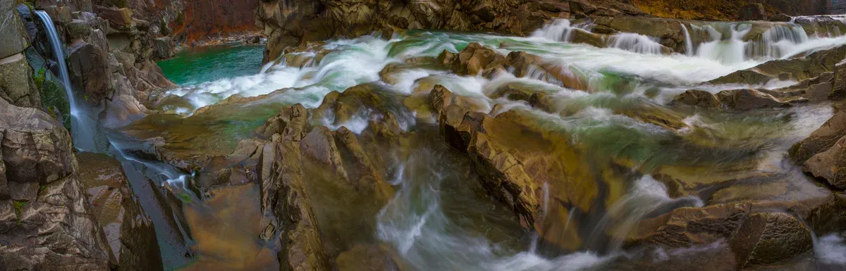
Probiy waterfall on the Prut in Yaremche. Photo: Nata Mostova, CC BY-SA 4.0, via Wikimedia Commons
What Is There to See at Probiy Waterfall and the Market?
Probiy is a cascade on the Prut that you watch from a pedestrian bridge, next to a market of embroidered clothing and wooden goods.
This is the short stop that everyone makes. The city council lists the Probiy and Huk waterfalls among Yaremche's attractions.
The Cascade and the Bridge
The Probiy waterfall is a cascade on the Prut within the territory of the second souvenir market in Yaremche. From the pedestrian bridge you watch the Prut rush through a rocky channel. The nearby market sells embroidered clothing and wooden goods.
A swinging pedestrian toll bridge is also listed among the town's sights. Carry small cash for the bridge and the stalls.
The Prut rises on the northern slopes of Chornohora above 1,750 m. Rafting competitions run on it every year, with amateur rafting and kayak trips.
Source: Yaremche city council.
What Is the Dovbush Trail?
It is an easy 4 km eco-trail of about 3 hours above the Prut canyon, starting 2.5 km from Yaremche railway station.
Wear grippy shoes, especially after rain. The trail leads through woods above the Prut to rocks tied to the outlaw Oleksa Dovbush.
Route and Stops
The Dovbush Trail is in the Dribka tract on the right bank of the Prut, overlooking the Prut canyon. It starts near the Dovbush Stone on the Lviv-Mukachevo highway, about 2.5 km from Yaremche railway station.
- The Panshchyna meadow stone composition, from 1990, with a stone cross dated 1848. - The Opryshky composition of three stones. - Dovbush's stone storehouse, where legend hides a treasure visible on Ivan Kupala night.
| Trail | Length | Time | Level |
|---|---|---|---|
| Dovbush Trail | 4 km | about 3 h | Easy |
What Is in Dora, and What Is Slon Rock?
Dora has the wooden Church of St. Elijah on a monastery's grounds, and Slon Rock shows rock layers bent into sharp Gothic folds above the Prut.
Dora is now part of Yaremche. The two stops fit a half day with the Dovbush Trail.
Dora and the Church of St. Elijah
Dora, now part of Yaremche, has the wooden Church of St. Elijah on a Studite monastery's grounds. The Museum of Metropolitan Andrey Sheptytsky is in St. Andrew's Monastery grounds in Dora hamlet. It has no fixed hours, so arrange visits in advance on (03434) 3-33-99.
Slon Rock
Slon Rock shows layered rock bent into sharp Gothic folds above the Prut. Wear grippy shoes, as on the Dovbush Trail.
Source: Yaremche city council.
Which Museums and Visitor Centres Are in Yaremche?
The Museum of Ecology and Ethnography is open 10:00-18:00 and closed Monday, and the Ecotourism Visitor Centre is open 10:00-17:00 daily.
Both are a good wet-weather stop in a town where the main sights are outdoors.
Opening Hours and Addresses
The Ecotourism Visitor Centre is inside the Carpathian National Nature Park, was built in 2008 with EU support and has a souvenir shop and info kiosk.
| Place | Address | Hours | Phone |
|---|---|---|---|
| Museum of Ecology and Ethnography of the Carpathian Region | vul. Svobody 269 | 10:00-18:00, closed Monday | (03434) 2-22-08 |
| Ecotourism Visitor Centre | vul. V. Stusa 6 | 10:00-17:00, no days off | (03434) 2-22-59 |
| Museum of Metropolitan Andrey Sheptytsky | Dora hamlet | No fixed hours, by arrangement | (03434) 3-33-99 |
Source: Yaremche city council.
What Is the Carpathian National Nature Park?
The park was created in 1980, covers 505.1 sq km from Chornohora down to Yaremche and lists 16 eco-trails.
Yaremche is the gateway to it, and Hoverla's trail lies inside it.
Size and Trails
The park covers 500-2,061 m on the north-eastern slopes of the Ukrainian Carpathians, from the Chornohora watershed down to Yaremche along the Prut. It says it has 300 km of trails and that the most popular season runs from April to November. Its 16 eco-trails include Mount Hoverla, Mount Pip Ivan, Dovbush Trail, Mount Makovytsia, To the Oldest Tree, Huk waterfall and Divochi Slozy waterfall.
The park sells guided excursions on the Makovytsia, Hoverla, Dovbush trail and Hoverlianskyi eco-trails, priced at its visitor centre. For the wider range, see the Carpathian Mountains in Ukraine.
How Much Time to Spend in Yaremche?
A short stop is Probiy and the market, half a day adds the Dovbush Trail or Dora, and a full day adds Vorokhta.
Plan it as a half-day outing and add a second stop only if the weather holds.
A Timed Plan
The Dovbush Trail alone takes about 3 hours, so a half day means one walk plus the waterfall. In Vorokhta, four stone viaducts were built in 1894-1895 under Austro-Hungary, 130 m, 200 m, 185 m and 170 m long. Two of them have newer bridges beside them (2000) that no longer operate.
| Time | Plan |
|---|---|
| Short stop | Probiy waterfall and the market |
| Half a day | Add the Dovbush Trail or Dora |
| Full day | Add Vorokhta and its viaducts |
How Far Is Yaremche from Bukovel?
Yaremche is on the 110 km road from Ivano-Frankivsk to Bukovel, so you pass it on the way.
From Ivano-Frankivsk the resort is 110 km via Nadvirna, Yaremche, Mykulychyn and Tatariv. Ask your hotel to quote the transfer time for the day you go.
Getting There
A resort shuttle bus runs between Tatariv-Bukovel railway station and the resort. A free daily bus from Yaremche to MAVKA aquapark, the resort's water park, has been announced, and the resort publishes news on its site. The resort taxi can be reached at +38 (067) 444 7 808. Hotels are listed under where to stay in Bukovel.
From Yaremche you can reach Vorokhta by bus or taxi, which is the road toward the foot of Hoverla. Beyond the town, the highest peak has its own route in climbing Hoverla.
Weather for the Outing
These are Bukovel valley averages from ERA5 reanalysis, 1995-2024, for planning. Yaremche lies lower, at about 580 m.
| Month at Bukovel | High | Low | Rainy days |
|---|---|---|---|
| May | 15.4°C | 6.2°C | 17.9 |
| June | 18.8°C | 10.2°C | 19.2 |
| July | 20.4°C | 11.9°C | 19.6 |
| August | 20.4°C | 11.7°C | 15.4 |
| September | 15.5°C | 7.5°C | 13.1 |
| October | 10.7°C | 2.9°C | 10.6 |
Sources: Bukovel resort, Bukovel resort, Copernicus ERA5.
Can You Visit Yaremche Now?
Ukraine is at war, and the UK advises against all but essential travel to Ivano-Frankivsk region, so check is Bukovel open first.
Yaremche lies in Ivano-Frankivsk region. Canada's advisory reads Avoid all travel, and Ukraine's airspace is closed.
What the Advisories Say
FCDO says attacks can and do also happen in the western regions, so be ready to take shelter when an air alert is announced. It also warns that travel insurance could be invalidated if you travel against its advice. Keep an air raid alert app such as Air Alert, and know what curfews are in place.
Sources: UK Foreign Office, Government of Canada.
Yaremche FAQ
What is Yaremche weather like?
The nearby Bukovel valley averages 20.4°C highs in July and August and -2.2°C in January, and Yaremche lies lower at about 580 m. See the Bukovel ski resort for the winter side.
Where is Yaremche on the map?
It lies on the Prut in Nadvirna Raion of Ivano-Frankivsk Oblast, on the 110 km road from Ivano-Frankivsk to Bukovel. See the Bukovel ski resort for the resort end of the road.
Is the Dovbush Trail hard?
No, it is an easy 4 km eco-trail of about 3 hours. Wear grippy shoes after rain, and see where to stay in Bukovel if you want to stay overnight.
Can you reach Hoverla from Yaremche?
Yes, take a bus or taxi to Vorokhta and then a car or taxi to Zarosliak. See the Bukovel ski resort page for the wider region.
Is there anything to do in Yaremche in rain?
The Museum of Ecology and Ethnography is open 10:00-18:00, closed Monday, and the Ecotourism Visitor Centre is open 10:00-17:00 daily. See is Bukovel open before travelling.
More Guides
- What Is There to See in the Carpathian Mountains of Ukraine?
Hoverla at 2,061 m, Yaremche, lakes and Bukovel skiing: what to see in the Carpathian Mountains of Ukraine. Plan your 2027 trip.
- How Do You Climb Hoverla, Ukraine's Highest Mountain?
How to climb Hoverla (2,061 m): blue and green paths, 3-3.5 h up, park rules and season. Plan your 2027 hike with this guide.
- Bukovel Hotels: Where Should You Stay?
Bukovel hotels by area: 4 bases, 3 resort hotels next to ski-lifts and spa options. Read before you plan 2027.