 Bukovel Tours
Home › Guides › How Do You Climb Hoverla, Ukraine's Highest Mountain?
How Do You Climb Hoverla, Ukraine's Highest Mountain?
Hoverla is Ukraine's highest mountain at 2,061 m, and the climb from the Zarosliak base is 3.5 km on the blue path or 4 km on the green, about 3-3.5 hours up. It sits in the same part of the Ukrainian Carpathians as the Bukovel ski resort, reached by road through Yaremche and Vorokhta.
Quick answer Height, route and time in brief
Hoverla is 2,061 m, the highest mountain in Ukraine. From the Zarosliak base the climb is 3.5 km on the blue path or 4 km on the green one, about 3-3.5 hours up and up to 2 hours down.
Key takeaways
- Start at Zarosliak above Vorokhta, reached by road from the Bukovel ski resort side via Yaremche.
- Pick the green path for gentler going or the blue path for the shortest line, and read where to stay in Bukovel if you want a base for the night before.
- Allow a full day and be at the checkpoint when it opens at 7:00, so you top out before noon as the park advises.
- Check whether Bukovel is open and what governments advise before you plan anything.
How High Is Hoverla and Where Is It?
Hoverla rises to 2,061 m on the Chornohora ridge in Ivano-Frankivsk Oblast, on the border with Zakarpattia.
The Bukovel ski resort lies in Polianytsia between the Gorgany and Chornohora ranges, so the mountain is in the same part of the Ukrainian Carpathians, but a different range.
Hoverla at a Glance
The park calls the Chornohora ridge the highest massif in Ukraine. Five other peaks over 2,000 m stand in the area, among them Pip Ivan and Petros.
| What | Detail |
|---|---|
| Height | 2,061 m |
| Range | Chornohora, Eastern Beskids |
| Standard start | Zarosliak base above Vorokhta |
| Climb from Zarosliak | 3.5 km blue, 4 km green |
What Is on the Summit
A 5 m stela with the national trident and flag has stood on the top since 1996.
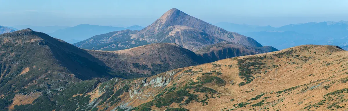
Hoverla and the Chornohora massif. Photo: Nata Mostova, CC BY-SA 4.0, via Wikimedia Commons
Which Route Should You Take, Blue or Green?
Both popular routes start at Zarosliak, the green path is longer and gentler with better ridge views, and the blue path is steeper.
The steeper route is marked blue, the gentler and longer one green.
Blue and Green from Zarosliak
The green path is a bit gentler and gives better views of the ridge between Mala Hoverla and Hoverla. The distance differs little, so the slope is what you feel.
AllTrails rates the Zarosliak route as hard: 4.4 mi with 2,562 ft of gain, about 4-4.5 hours.
| Route | Length | Character | Up | Down |
|---|---|---|---|---|
| Blue from Zarosliak | 3.5 km | Steeper | about 3-3.5 h | up to 2 h |
| Green from Zarosliak | 4 km | Gentler, better ridge views | about 3-3.5 h | up to 2 h |
| Kozmeshchyk via Lazeshchyna | about twice as long | Gentler | about 8 h total | included |
The Park's Own Eco-trail
The park's eco-trail is rated hard, 10.5 km long and about 5 hours, running from 950 m to 2,061 m. It starts at the checkpoint of the Hoverla ranger station in the Zavoiev tract near Vorokhta. It follows a forest road along the Prut past the Zarosliak base, then climbs through spruce forest to alpine meadows.
On the way you pass old-growth spruce and the Huk waterfall, with views of Chornohora and the Gorgany ridges.
How Long Does the Hoverla Hike Take?
From Zarosliak plan about 3-3.5 hours up and up to 2 hours down, plus time on the top.
Start early. The park advises reaching the summit before noon, and its summer checkpoint hours are 7:00 to 12:00.
A Day Plan from the Checkpoint
The park page lists summer hours of 7:00 to 12:00 at the checkpoint and advises reaching the summit before noon. From Zarosliak the climb takes about 3-3.5 hours up and up to 2 hours down.
Rain, thunderstorms and strong wind are common. In April the national park guard refused entry to one hiker after an accident in fog and avalanche.
| Step | Distance | Time |
|---|---|---|
| Zarosliak to the summit, blue | 3.5 km | about 3-3.5 h |
| Zarosliak to the summit, green | 4 km | about 3-3.5 h |
| Summit to Zarosliak | same path | up to 2 h |
How Do You Get to the Hoverla Trailhead from Bukovel?
Go to Vorokhta by road via Yaremche, then take a car or taxi to Zarosliak, so ask your hotel how long the drive takes.
Build the day around Yaremche and Vorokhta.
By Bus or Taxi Through Yaremche
From Yaremche take a bus or taxi to Vorokhta. The park says to take a bus from Yaremche toward Verkhovyna, get off at the 6th kilometre in Vorokhta (the turn to Zarosliak) and walk about 4 km to the checkpoint, or take a taxi from Vorokhta bus station to Zarosliak. From the checkpoint to the Zarosliak base is about 8 km on a forest road that vehicles can use, then about 4 km of marked trail to the summit.
Both popular routes start at Zarosliak, reached by car or taxi from Vorokhta. Bukovel's own site gives 110 km from Ivano-Frankivsk to the resort via Nadvirna, Yaremche, Mykulychyn and Tatariv. The distance and time from Bukovel to Vorokhta are not given, so ask your hotel or a local driver to quote the transfer and agree the pick-up for the descent. The road runs through Yaremche, a good place to break the journey.
By Train
Vorokhta is about 200 km from Lviv by train, which took six and a half hours. A resort shuttle bus runs between Tatariv-Bukovel railway station and Bukovel. Hotels are listed under where to stay in Bukovel.
Source: Bukovel resort.
When Is the Best Time to Climb Hoverla, and Can You Climb in Winter?
Summer is the easiest, and Hoverla is climbable all year, but winter brings avalanche danger from December to March.
The park says the most popular season runs from April to November.
Summer, Shoulder Season and Winter
The summit can be +15 when the valleys are +25. Snow on Hoverla in summer is not unusual, according to the park. In April there is still much snow, crampons cannot be hired in Vorokhta, and the best advice is to climb in the morning when the snow is frozen.
Hoverla is climbable all year, with avalanche danger in winter. The reserve puts the avalanche period at December to March depending on snow cover, and also warns of floods after heavy rain, mudflows, fog, sun exposure and night hiking. Follow the park guards. FCDO notes temperatures may drop below -20°C during winter in Ukraine. For the other season in these mountains, see ski resorts in Ukraine.
| Month at Bukovel | High | Low | Snowfall |
|---|---|---|---|
| May | 15.4°C | 6.2°C | 0 cm |
| June | 18.8°C | 10.2°C | 0 cm |
| July | 20.4°C | 11.9°C | 0 cm |
| August | 20.4°C | 11.7°C | 0 cm |
| September | 15.5°C | 7.5°C | 0 cm |
| October | 10.7°C | 2.9°C | 3.8 cm |
| November | 5.2°C | -1.3°C | 17.0 cm |
How to Read the Table
These are Bukovel valley averages from ERA5 reanalysis, 1995-2024, not summit readings. Rain falls on 19.6 days in July at Bukovel, so carry a shell even in good weather.
Sources: Copernicus ERA5, UK Foreign Office.
What Should You Pack and What Are the Park Rules?
Pack a 20-25 L day pack with a warm layer, rain jacket, 1-1.5 L of water and a light, and keep to the marked route.
Register at the checkpoint, where staff brief you on conduct and mountain safety. The park advises hiring a guide.
What to Carry
- Day pack of 20-25 L. - Warm layer and rain jacket. - First aid kit with a thermal blanket. - Phone with GPS, plus a flashlight. - 1-1.5 L of water and food.
The summit can be +15 when the valleys are +25, so a warm layer is not optional.
What the Park Forbids
Prohibited in the park: leaving the marked route, damaging natural objects, fires outside designated places, smoking in forest, cutting trees, picking flowers or medicinal plants, hunting, fishing, firearms, littering and loud noise.
The park asks hikers to tell the State Emergency Service (DSNS) about the trip through its online mountain-rescue form and to save the local rescue unit contacts. Tourist groups must register with the control and rescue unit before setting out.
How Much Does It Cost to Climb Hoverla?
The park charges a small entry fee at the checkpoint, paid in cash, so carry hryvnias.
You pay at the checkpoint and register there.
Checkpoint Fee and Guided Walks
The park charges a small entry fee at the checkpoint, paid in cash, so carry hryvnias in small notes. Summer checkpoint hours are 7:00 to 12:00.
The park sells guided excursions on these trails, priced at its visitor centre.
Can You Climb Hoverla Now?
Ukraine is at war, and the UK advises against all but essential travel to Ivano-Frankivsk region, so check is Bukovel open first.
Hoverla's eastern side, where the Zarosliak path starts, lies in Ivano-Frankivsk region. The UK Foreign Office advises against all but essential travel there and to the other western regions it lists. Canada's advisory reads Avoid all travel, and Ukraine's airspace is closed.
What the Advisories Say
FCDO warns that Russian missile and drone attacks can happen in the western regions, so be ready to take shelter immediately when an air alert is announced. It also warns that travel insurance could be invalidated if you travel against its advice.
Heading into the border strip needs a permit. Staying in the border strip in Rakhiv district needs a free permit from the 27th Border Detachment in Mukachevo, issued within 10 working days. Check access with the park before you choose the Zakarpattia side.
Sources: UK Foreign Office, Government of Canada, Bychkivska council.
Hoverla FAQ
How high is Hoverla in feet?
Hoverla is 2,061 m, which is 6,762 ft, and it is the highest mountain in Ukraine. See Bukovel Tours for the wider region.
Where does the Hoverla hike start?
Most hikers start at the Zarosliak base, reached by car or taxi from Vorokhta. The park's checkpoint is about 8 km before it by forest road. The Bukovel ski resort side reaches it through Vorokhta.
Is there a gentler way up Hoverla?
The green path from Zarosliak is a bit gentler, and the Kozmeshchyk route from the Zakarpattia side is about twice as long but gentler, about 8 h total. The Bukovel ski resort is on the other range.
Can you hike Hoverla in winter?
Yes, it is climbable all year, but the avalanche period runs December to March. Follow the park guards. Check is Bukovel open first.
More Guides
- What Is There to See in the Carpathian Mountains of Ukraine?
Hoverla at 2,061 m, Yaremche, lakes and Bukovel skiing: what to see in the Carpathian Mountains of Ukraine. Plan your 2027 trip.
- What Is There to Do in Yaremche Near Bukovel?
What to do in Yaremche: Probiy waterfall, the 4 km Dovbush Trail and Dora. Plan a half day on your 2027 Carpathian trip.
- Which Ski Resorts in Ukraine Are Worth the Trip?
58 ski resorts in Ukraine compared: Bukovel, Dragobrat, Pylypets, slopes, lifts and snow. Pick your resort for 2027.