 Bukovel Tours
Home › Guides › What Is There to See in the Carpathian Mountains of Ukraine?
What Is There to See in the Carpathian Mountains of Ukraine?
For Carpathian Mountains Ukraine trips, the top things to see are Hoverla at 2,061 m, the Probiy waterfall at Yaremche, mountain lakes and skiing at Bukovel. This guide gives the time each takes and how to reach it.
Quick answer What to see in the Ukrainian Carpathians
The Ukrainian Carpathians are best known for Hoverla, at 2,061 m the highest point in Ukraine, and for skiing at Bukovel in winter. The Carpathian National Nature Park around Yaremche has 300 km of trails, and its busiest season runs from April to November.
Key takeaways
- Base yourself near Bukovel ski resort for winter skiing and summer hiking.
- Sleeping near the mountains is covered on where to stay in Bukovel.
- Hoverla is a hard 10.5 km trail of about 5 hours, so plan a full day from a base such as Bukovel.
- Read is Bukovel open before planning any trip to the region.
Where Are the Carpathian Mountains in Ukraine?
They cover parts of Zakarpattia, Lviv, Ivano-Frankivsk and Chernivtsi regions, within a mountain arc of 1,500 km through eastern Europe.
The Ukrainian part is made of several ranges. Three of them matter most to a visitor.
The Ranges
The subranges include Gorgany, Svydovets and Chornohora. Bukovel sits in Polianytsia village in Ivano-Frankivsk region, between the Gorgany and Chornohora ranges. Chornohora is the range that carries Hoverla, and the park calls it the highest massif in Ukraine.
Five other peaks over 2,000 m stand in the same area: Pip Ivan, Brebeneskul, Hutin Tomnatyk, Rebra and Petros. Tomnatyk still carries the remains of a Pamir radar on the Romanian border.
The Prut, the main river of the national park, begins a few hundred metres below the Hoverla summit and runs down to Yaremche. The main base for the region is Bukovel ski resort.
Source: Bukovel resort.
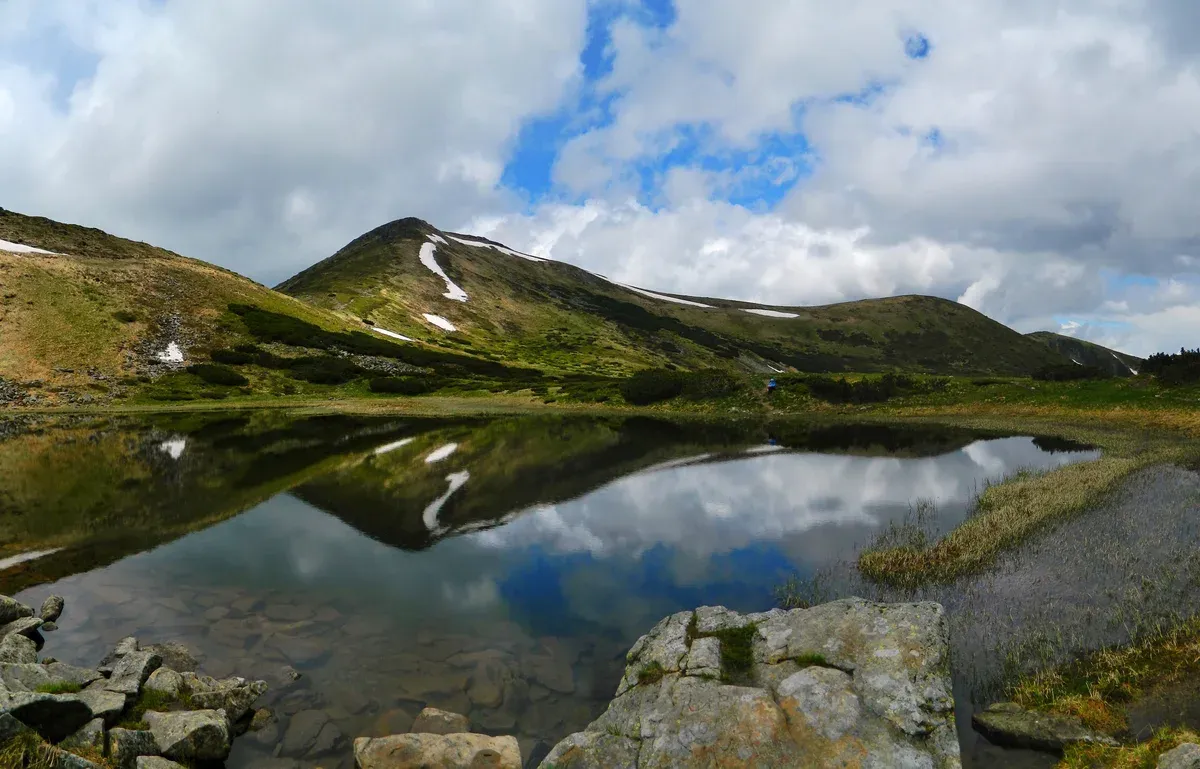
Lake Nesamovyte below the Chornohora ridge. Photo: Mykola Swarnyk, CC BY-SA 3.0, via Wikimedia Commons
How Hard Is the Climb up Hoverla?
The park rates the Hoverla eco-trail as hard, 10.5 km and about 5 hours.
Hoverla is 2,061 m above sea level, and the trail climbs from 950 m to the summit.
The Route
The trail starts at the checkpoint of the Hoverla ranger station in the Zavoiev tract near Vorokhta. It follows a wide forest road along the Prut, then climbs through spruce forest to alpine meadows. Forest reaches about 1,100 m, the upper forest limit is 1,400 to 1,450 m and the alpine meadows begin at about 1,800 m.
From the checkpoint to the Zarosliak sports base it is about 8 km on a forest road that vehicles can use, then about 4 km of marked trail to the summit. The trail is waymarked with white horizontal stripes and a centre stripe. Along the way you pass old-growth spruce and the Huk waterfall, with views of Chornohora, the Gorgany ridges and Petros at 2,020 m.
One blogger calls the grassy top an easy walk, but the park rates the trail hard.
Before You Set Out
Register at the checkpoint, where staff brief visitors on conduct and mountain safety. The park's page advises reaching the summit before noon and lists summer hours of 7:00 to 12:00. The park charges a small entry fee at the checkpoint, paid in cash, so carry hryvnias. The park sells guided excursions on these trails, priced at its visitor centre.
Tell the State Emergency Service about the trip through its online mountain-rescue form and save the local rescue unit contacts. Snow on Hoverla in summer is not unusual, and the reserve says the snow usually melts in July, though not every year.
Getting there: from Yaremche take a bus or taxi to Vorokhta. For the Hoverla trail, take a bus toward Verkhovyna, get off at the 6th kilometre in Vorokhta and walk about 4 km to the checkpoint, or take a taxi from Vorokhta bus station to Zarosliak. The full route is in climbing Hoverla.
Where Can You Ski in the Carpathians?
Bukovel is the main ski resort of the Carpathians, with slopes from 850 to over 1,300 metres above sea level.
Skiing is the winter reason to come, and hiking is the summer one.
Bukovel and Dragobrat
Bukovel's own history page says its slope network grew beyond 50 km and later exceeded 70 km, and the first lift opened in 2003. Bukovel sells a night pass valid from 21:00 to 24:00. The resort is 110 km from Ivano-Frankivsk by road.
Dragobrat calls itself the highest-altitude ski resort in Ukraine, at about 1,400 m in Zakarpattia region, and its season starts in November. For the full resort comparison see the Bukovel ski resort pages.
Bukovel works in summer too. It lists a rodelbahn toboggan run 1,500 m long, a bike park, hikes to Malyi Gorgan, Khomiak and Syniak, and Lake of Youth, over 6 hectares and up to 15 m deep, where the water runs 20 to 23°C in summer.
Source: Bukovel resort.
What Is There to See Around Yaremche?
Yaremche has the Probiy and Huk waterfalls, the Dovbush Trail and the Carpathian National Nature Park visitor centre.
Yaremche is the gateway to the national park, which covers 505.1 sq km from the Chornohora watershed down along the Prut.
Short Stops
The Probiy waterfall is a cascade on the Prut inside the second souvenir market in Yaremche. The Dovbush Trail is an easy 4 km eco-trail of about 3 hours on the right bank of the Prut, overlooking the canyon. It starts near the Dovbush Stone, about 2.5 km from Yaremche railway station. Stops include a stone cross dated 1848 and Dovbush's stone storehouse, where legend hides a treasure.
The Ecotourism Visitor Centre at vul. V. Stusa 6 is open from 10:00 to 17:00 with no days off, and the Museum of Ecology and Ethnography is open from 10:00 to 18:00 and closed on Monday. Yaremche town was first mentioned in 1787, and the railway came in 1893-94.
In Vorokhta, four stone viaducts built in 1894-1895 under Austro-Hungary are 130 m, 200 m, 185 m and 170 m long. The town has its own plan in Yaremche.
Things to Do Compared
The table puts the main activities side by side.
| Place | What it is | Time | Level |
|---|---|---|---|
| Hoverla eco-trail | Summit of Ukraine, 2,061 m | About 5 hours | Hard |
| Dovbush Trail | Canyon and legend stops | About 3 hours | Easy |
| Lake Nesamovyte | Glacial lake at 1,750 m | 14 km route from Zarosliak | Adventure route |
| Probiy waterfall | Cascade on the Prut | A short stop | Easy |
| Bukovel slopes | Network of over 70 km | Day or night passes | All levels |
Source: Yaremche city council.
Which Lakes, Forests and Reserves Are Worth Visiting?
Lake Nesamovyte, Synevyr and the Carpathian Biosphere Reserve are the main nature stops beyond Hoverla.
The wild side of the Carpathians is large, and much of the reserve is closed to walkers.
Lakes
Lake Nesamovyte lies at 1,750 m in a glacial cirque near Mount Turkul in the Chornohora massif. It is 88 m long and 45 m wide, and it freezes through in winter. The park lists a 14 km adventure route from Zarosliak with 521 m of elevation gain.
Synevyr is the largest mountain lake in Ukraine, 989 m above sea level. Synevyr National Nature Park covers 430 sq km, with 13 hiking routes totalling 138 km, and entry to the lake territory is paid at the gate.
Forests and Wildlife
The Carpathian National Nature Park is Ukraine's first and largest national park, created in 1980 and covering 51,571 hectares. The region holds Europe's largest tracts of primeval forest and the largest montane populations of wolves, lynxes and brown bears.
The Carpathian Biosphere Reserve covers 58,035.8 ha in 8 separate massifs in Zakarpattia, with 35 alpine lakes and 21 tourist trails. Primeval beech forests of 20,980.5 ha were added to the World Natural Heritage List in 2007. Stay on permitted trails.
The tougher Pop Ivan Marmaroskyi hike is 21 km and about 12 hours from Dilove village, about 50 m from the Romanian border, and it needs registration with the border service. Staying in the border strip in Rakhiv district needs a free permit from the 27th Border Detachment, issued within 10 working days.
Source: Bychkiv council.
What Are the Hutsuls, the Carpathian Tram and the Local Food?
Hutsuls, Boikos and Lemkos live in the Carpathians, and the narrow-gauge Carpathian tram and banusz are the two things to try.
Culture here is mountain culture, and a few stops make it easy to see.
People, Train and Plate
Three groups live here: Hutsuls, Boikos and Lemkos. The Carpathian narrow-gauge train in Vyhoda is one of four operating lines in Ukraine and was named the Carpathian tram in 2003. It is an Austro-Hungarian railway.
Banusz is cornmeal with sheep-milk cheese, pork rind and mushrooms. Bukovel's own Hutsul Land attraction is listed among its winter and summer activities.
The Museum of Metropolitan Andrey Sheptytsky stands in the grounds of St. Andrew's Monastery in Dora hamlet, with no fixed hours, so visits are arranged in advance.
Sources: Bukovel resort, Yaremche city council.
When Is the Best Time to Visit the Carpathians?
Hike from April to November and ski from early December to mid-April.
The park calls April to November its most popular season, and the avalanche period runs from December to March depending on snow cover.
Season by Season
At Bukovel, July highs reach 20.4°C with about 141 mm of rain over 19.6 rainy days. January averages a high of -2.2°C and a low of -7.9°C, with about 29.1 cm of snowfall. October averages 10.7°C at the top and 2.9°C at the bottom.
The reserve also warns about floods after heavy rain, mudflows, fog, sun exposure and night hiking.
To stay overnight, see where to stay in Bukovel.
Source: Copernicus ERA5.
How Do You Get to the Ukrainian Carpathians?
Go via Ivano-Frankivsk: Bukovel is 110 km away, and a resort shuttle meets the Tatariv-Bukovel railway station.
Ukraine's airspace is closed, so the route is overland, and the UK Foreign Office advises against all but essential travel to Ivano-Frankivsk region. Check is Bukovel open.
Routes
Coming from any Ukrainian city except Chernivtsi or Uzhhorod, drive to Ivano-Frankivsk first, then follow the road via Nadvirna, Yaremche, Mykulychyn and Tatariv. The resort's GPS location is 48.353886, 24.412860, and Ivano-Frankivsk region has two villages named Polianytsia, so check the coordinates.
For Rakhiv, buses run from Uzhhorod and Ivano-Frankivsk, and trains from Lviv, Kyiv, Odesa, Kharkiv and Ivano-Frankivsk. By road Rakhiv is 679 km from Kyiv, 273 km from Lviv and 208 km from Uzhhorod.
British and Canadian passport holders can enter without a visa for up to 90 days within a 180-day period.
Sources: Bukovel resort, UK Foreign Office.
Carpathian Mountains FAQ
What is the highest mountain in the Carpathians of Ukraine?
Hoverla, at 2,061 m, on the Chornohora range. The nearest big base is Bukovel ski resort.
Does it snow on Hoverla in summer?
The park says snow in summer is not unusual, and the reserve says it usually melts in July. Winter conditions are described on Bukovel.
Do hikers need to register?
Yes, groups register at the control and rescue unit before setting out, and hikers should send the online mountain-rescue form. Current conditions are on is Bukovel open.
Can you visit the Ukrainian Carpathians now?
Advice is against all but essential travel to Ivano-Frankivsk region, and Ukraine's airspace is closed. See is Bukovel open for the current position.
Where can you stay near the mountains?
Bukovel is the main base, see where to stay in Bukovel for areas and hotels.
More Guides
- Bukovel Hotels: Where Should You Stay?
Bukovel hotels by area: 4 bases, 3 resort hotels next to ski-lifts and spa options. Read before you plan 2027.
- What Is There to Do in Yaremche Near Bukovel?
What to do in Yaremche: Probiy waterfall, the 4 km Dovbush Trail and Dora. Plan a half day on your 2027 Carpathian trip.
- How Do You Climb Hoverla, Ukraine's Highest Mountain?
How to climb Hoverla (2,061 m): blue and green paths, 3-3.5 h up, park rules and season. Plan your 2027 hike with this guide.